Agriculture
June 11, 2024
Agropestalert
Read SolutionImplemented by
Agropestalert
Updated on June 11, 2024
·Created on October 8, 2018
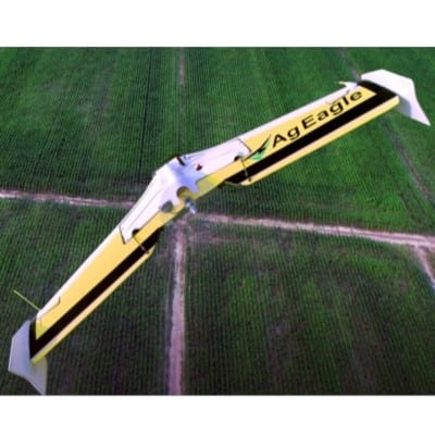
Drone for precision agriculture mapping
AgEagle RX40 is a professional drone that captures aerial maps for precision agriculture growers
Target SDGs
SDG 2: Zero Hunger
SDG 1: No Poverty
Market Suggested Retail Price
$8,766.00
Target Users (Target Impact Group)
Household
Distributors / Implementing Organizations
AgEagle Aerial Systems
Competitive Landscape
Direct competitors include Honeycomb AgDrone, Wings for Aid, and Drones for Development Dr.One.
Countries
Brazil, Ukraine, United States
Manufacturing/Building Method
Designed and built in the US using “Tractor Tough” airframes
Intellectural Property Type
Copyright
User Provision Model
Direct sales and authorized dealers
Distributions to Date Status
Unknown
Drone type
Fixed Wing (Flying Wing)
Weight (kg)
1.95
Take off / Landing type
Hand launch / Auto landing, power off glide
Carry case dimensions (m)
Unknown
GNSS system
Dual GPS (L 1 /L 2 & Glonass) NEO8
Flight time (hour)
44 mins
Cruise speed (km per hour)
53.1
Battery type
One Li-Po Battery (6600 mAh; 14.8V; 10C; 4 Cell)
Sensors available (Y/N)
Barometric Altimeter, Airspeed Indicator, 2 x Accelerometer, 2 x Gyroscope, 2 x Magnetometer, GPS, Glonass
Type of data collected
Pictures (Resolution 10.830 cm / pixel size at 121.92 m AGL
Drone software platform
Android tablet app
Application
Agricultural mapping
Design Specifications
Composition: Composite/EPP/Carbon Fiber Rod
Measurements: Wingspan: 47? (120 cm)
Weight: Max Gross T.O.: 4.4 lb (2 kg)
Fuel/Energy System: Single Li-Po, 6600 mAh; 14.8V; 10C; 4 Cell
Take-Off Method: Manual
Landing Method: Belly Landing
Flight Performance: Operating Airspeed: 31-36 mph (13.8-16 m/s)
Endurance: Up to 50 mins. w/ Std. Batteries
Technical Support
Local support from AgEagle dealers
Replacement Components
Available online
Lifecycle
One or two years repair and replacement plans available for an extra charge
Manufacturer Specified Performance Parameters
Vetted Performance Status
Unknown
Safety
Safety information included in the user manual
Complementary Technical Systems
Catapult launcher for fixed wing drone
Academic Research and References
Charles M. Boozer, Michael J. Van Tooren, and Ali Elham. “Multidisciplinary Aerodynamic Shape Optimization of a Composite Blended Wing Body Aircraft“, 58th AIAA/ASCE/AHS/ASC Structures, Structural Dynamics, and Materials Conference, AIAA SciTech Forum, (AIAA 2017-0128)
https://doi.org/10.2514/6.2017-0128
Atole, R., Belo, L. and Lirang, J. “Eyes in the Sky: A Review of Civilian Unmanned Aerial Vehicles (UAVs)” , International Journal of Computer Applications (0975 – 8887) Volume 173 – No.6, September 2017
Moskvitch, K. “Take off: are drones the future of farming?“, IET Volume 10, Issue 7, August 2015, p. 62 – 66
I. Petkovics, J. Simon, Á. Petkovics and Z. ?ovi?, “Selection of unmanned aerial vehicle for precision agriculture with multi-criteria decision making algorithm,” 2017 IEEE 15th International Symposium on Intelligent Systems and Informatics (SISY), Subotica, 2017, pp. 000151-000156.
doi: 10.1109/SISY.2017.8080543
Dehaan, R. “Evaluation of Unmanned Aerial Vehicle (UAV)-Derived imagery for the detection of Wild Radish in Wheat” December 2015
“About.” 2022. AgEagle Aerial Systems Inc. July 13, 2022. https://ageagle.com/about/
“THE 17 GOALS.” n.d. Sdgs.Un.Org. Accessed June 12, 2024. https://sdgs.un.org/goals
“Find a Partner.” 2022. AgEagle Aerial Systems Inc. July 25, 2022. https://ageagle.com/find-partner/
“Compare Drones.” 2022. AgEagle Aerial Systems Inc. July 8, 2022. https://ageagle.com/compare-drones/
“AgEagle RX-48 – AgEagle – PDF Catalogs.” n.d. Aeroexpo.Online. Accessed June 12, 2024. https://pdf.aeroexpo.online/pdf/ageagle/ageagle-rx-48/176225-18209.html
“(PDF) Eyes in the Sky: A Review of Civilian Unmanned Aerial Vehicles (UAVs).” n.d. ResearchGate. Accessed June 12, 2024. https://www.researchgate.net/publication/319870747_Eyes_in_the_Sky_A_Review_of_Civilian_Unmanned_Aerial_Vehicles_UAVs
“Support.” 2022. AgEagle Aerial Systems Inc. July 28, 2022. https://ageagle.com/support/
Compliance with regulations
Compliance with US FAA regulation
Evaluation methods
Academic research
Other Information

Agriculture
June 11, 2024
Implemented by
Agropestalert

Agriculture
May 24, 2024
Implemented by
Esoko

Agriculture
August 20, 2024
Implemented by
Technology for Tomorrow (T4T) Africa
Agriculture
June 23, 2024
Implemented by
Motivo Engineering
Agriculture
January 6, 2025
Implemented by
Microsoft
Agriculture
August 21, 2024
Implemented by
Marius Rossouw design engineer Aflastop
Agriculture
February 12, 2024
Implemented by
Naireeta Services
Agriculture
January 22, 2024
Implemented by
Sparky Social Enterprise Ltd.
Agriculture
January 30, 2024
Implemented by
D.S. Khuridiya
Agriculture
September 19, 2024
Implemented by
Penn State HESE

Agriculture
June 11, 2024
Implemented by
Agropestalert

Agriculture
May 24, 2024
Implemented by
Esoko

Agriculture
August 20, 2024
Implemented by
Technology for Tomorrow (T4T) Africa

Agriculture
June 23, 2024
Implemented by
Motivo Engineering

Agriculture
January 6, 2025
Implemented by
Microsoft

Agriculture
August 21, 2024
Implemented by
Marius Rossouw design engineer Aflastop

Agriculture
February 12, 2024
Implemented by
Naireeta Services

Agriculture
January 22, 2024
Implemented by
Sparky Social Enterprise Ltd.

Agriculture
January 30, 2024
Implemented by
D.S. Khuridiya

Agriculture
September 19, 2024
Implemented by
Penn State HESE

Agriculture
June 11, 2024
Implemented by
Agropestalert

Agriculture
May 24, 2024
Implemented by
Esoko

Agriculture
August 20, 2024
Implemented by
Technology for Tomorrow (T4T) Africa

Agriculture
June 23, 2024
Implemented by
Motivo Engineering

Agriculture
January 6, 2025
Implemented by
Microsoft

Agriculture
August 21, 2024
Implemented by
Marius Rossouw design engineer Aflastop

Agriculture
February 12, 2024
Implemented by
Naireeta Services

Agriculture
January 22, 2024
Implemented by
Sparky Social Enterprise Ltd.

Agriculture
January 30, 2024
Implemented by
D.S. Khuridiya

Agriculture
September 19, 2024
Implemented by
Penn State HESE
Have thoughts on how we can improve?
Give Us FeedbackNotifications