
Agriculture
June 26, 2024
CGNet Swara
Read SolutionImplemented by
CGNet Swara
Updated on June 24, 2024
·Created on August 31, 2020
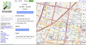
OpenStreetMap is an open-source project that aims to create a free editable map of the world and provide geospatial data to web sites, mobile apps, and hardware devices.
OpenStreetMap (OSM) is an open-source mapping tool that provides geospatial data to websites, mobile apps, or hardware devices. OSM is built by a community of developers and specialists in mapping that contribute and maintain data about roads, trails, cafés, railway stations, and more all over the world. Contributors use aerial imagery, GPS devices, and low tech field maps to verify that the data is accurate and up to date.
Target SDGs
SDG 16: Peace, Justice and Strong Institutions
Target Users (Target Impact Group)
Distributors / Implementing Organizations
OpenStreetMaps
Competitive Landscape
Direct competitors include Mapbox.
Regions
Worldwide
Manufacturing/Building Method
N/A
Intellectural Property Type
Select Type
User Provision Model
Users can use this tool for mapping by entering OpenStreetMaps' website. Developers can clone the project or contribute following the guidance on their Github repo.
Distributions to Date Status
As of 2020, OpenStreetMaps has reached more than 6 M users.
Geocoding supported (Y/N)
Yes
Visuals
Maps
Application
Mapping, app development
Type of data collected
Location
Data acquisition methods
Mobile app data collection, crowd sourced data, remote sensing, government census data
Open source code (Y/N)
Y
Open source data (Y /N/ Other)
Y
Data import/export formats
CSV, GeoJSON, MBTiles, KML, GPX, Shapefile, and GeoTiff
Telecommunication service required (Y/N)
Mobile or landline internet
Device(s) required
Computer, mobile phone or hardware device
Languages available (list)
English
Design Specifications
OpenStreetMap (OSM) is an open-source mapping tool that provides map data to websites, mobile apps, or hardware devices. OSM is built by a community of developers and specialists in mapping that contribute and maintain data about roads, trails, cafés, railway stations, and more all over the world. Contributors use aerial imagery, GPS devices, and low tech field maps to verify that the data is accurate and up to date.
The website and the API of OSM are written in Ruby On Rails, and the main server uses PostgreSQL as a database and PostGIS to store different types of geometry of geographic objects.
Product Schematics
Technical Support
This product does not offer technical support but it has several resources for learning about the project.
Replacement Components
N/A
Lifecycle
N/A
Manufacturer Specified Performance Parameters
This product aims to make mapping tools available to everyone.
Vetted Performance Status
Testing performed by the Department of Civil Engineering, Al-Matria Faculty of Engineering determined that OpenStreetMap data has a positional accuracy of 1.57 m which is suitable for generating planimetric maps of scale 1:5000 or smaller.
Safety
No known safety hazards are related to this product.
Complementary Technical Systems
A device with a basic internet connection.
Academic Research and References
Haklay, M., Weber, P., 2008, OpenStreetMap: User-Generated Street Maps. IEEE Pervasive Computing, Volume: 7.
Mooney, P., Corcoran, P., 2010, Winstanley A., 2010, Towards quality metrics for OpenStreetMap. 18th SIGSPATIAL International Conference on Advances in Geographic Information Systems.
Van Exel, M., Dias, E., Fruijtier, S. 2010, The impact of crowdsourcing on spatial data quality indicators. Vrije Universiteit, FEWEB/RE
Luxen, D., Vetter C., 2011, Real-time routing with OpenStreetMap data. 19th SIGSPATIAL International Conference on Advances in Geographic Information Systems.
El-Ashmawy, K. l., 2016, Testing the positional accuracy of OpenStreetMap data for mapping applications. Geodesy and Cartography, 42(1), 25-30.
Mooney, P., Corcoran, P., 2012, The Annotation Process in OpenStreetMap. Transaction in GIS, Volume16, Issue4.
“OpenStreetMap.” n.d. OpenStreetMap. Accessed June 24, 2024. https://www.openstreetmap.org/
“HERE Technologies.” n.d. Here.Com. Accessed June 24, 2024. https://www.here.com/
“TomTom — Maps and Location Technology.” n.d. TomTom. Accessed June 24, 2024. https://www.tomtom.com/
“Goal 16.” n.d. Sdgs.Un.Org. Accessed June 24, 2024. https://sdgs.un.org/goals/goal16
“Sign Up.” n.d. OpenStreetMap. Accessed June 24, 2024. https://www.openstreetmap.org/user/new
OpenStreetMap On. n.d. Accessed June 24, 2024. https://github.com/openstreetmap
“OpenStreetMap Statistics.” n.d. Openstreetmap.Org. Accessed June 24, 2024. https://planet.openstreetmap.org/statistics/data_stats.html
“OpenStreetMap.” n.d. OpenStreetMap. Accessed June 24, 2024. https://www.openstreetmap.org/about
“OpenStreetMap.” n.d. OpenStreetMap. Accessed June 24, 2024. https://www.openstreetmap.org/help
“View of Testing the Positional Accuracy of OpenStreetMap Data for Mapping Applications.” n.d. Vilniustech.Lt. Accessed June 24, 2024. https://journals.vilniustech.lt/index.php/GAC/article/view/2497/2018
Ciudad Autónoma de Buenos Aires), Usig (asi-Gobierno de la. n.d. “Acerca Del Mapa Interactivo de Buenos Aires.” Gob.Ar. Accessed June 24, 2024. https://mapa.buenosaires.gob.ar/static/acercade.html
“Rapid Editor.” n.d. Mapwith.Ai. Accessed June 24, 2024. https://rapideditor.org/#14/6.14921/6.76873
HarryWood, and ? View All Posts. n.d. “Apple Maps.” Openstreetmap.Org. Accessed June 24, 2024. https://blog.openstreetmap.org/2012/10/02/apple-maps/
“Terms of Use – OpenStreetMap Foundation.” n.d. Osmfoundation.Org. Accessed June 24, 2024. https://osmfoundation.org/wiki/Terms_of_Use
Compliance with regulations
According to their Terms of Service, Mapbox is in compliance with all local laws and regulations.
Evaluation methods
Integration of OpenStreetMap services in multiple platforms (applications/websites).
Other Information
Users can find more information in this video.
Agriculture
June 26, 2024
Implemented by
CGNet Swara

Agriculture
June 24, 2024
Implemented by
FixMyStreet

Agriculture
June 25, 2024
Implemented by
Media in Cooperation and Transition (MiCT)

Agriculture
June 20, 2024
Implemented by
Premise

Agriculture
June 25, 2024
Implemented by
RootIO
Agriculture
June 25, 2024
Implemented by
SeeClickFix
Agriculture
June 13, 2024
Implemented by
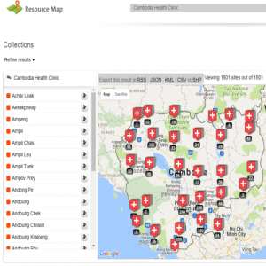
Resource Map
Agriculture
June 13, 2024
Implemented by
Pajat Solutions Ltd

Agriculture
June 9, 2024
Implemented by
Turkcell
Agriculture
June 13, 2024
Implemented by
Esri
Have thoughts on how we can improve?
Give Us Feedback