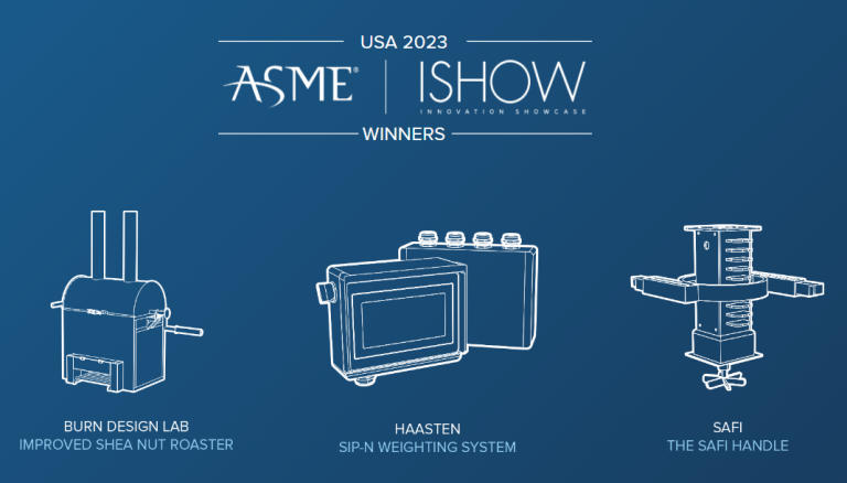
NEWS March 24, 2025

Satellites Could Reshape Small-Scale Farming

Space technologies can benefit small-scale farmers, according to a new report by the FAO and UNOOSA. Pictured are small garden plots in Bamako, Mali.

Mark Fischer (CC BY-SA 2.0)


Space tech may be the next frontier for global food security according to a new report from the UN’s Food and Agriculture Organization (FAO) and the United Nations Office for Outer Space Affairs (UNOOSA). Advancements in sensing technologies and the sheer number of satellites that launch every year — nearly 3000 — make imagery and data sharper, faster and more accessible than ever.

The accessibility can’t be overstated: Satellites are now streaming ultra-precise data straight to phones. But there’s a problem. In spite of the leaps, small-scale farmers and emerging economies still struggle with data access. And international coordination is a mess. To solve some of these problems, the report has laid out the following  recommendations:

  • Boost global capacity to use satellite data for agriculture. Invest in training and infrastructure to enable its effective use.
  • Coordinate satellite missions between nations to avoid redundancy. Align missions focused on agriculture.
  • Make satellite data open and interoperable for better access and integration. Ensure satellite data is easily accessible and compatible across platforms for seamless integration.
  • Create a UN imagery procurement hub to cut costs and improve efficiency. A centralized platform for acquiring satellite imagery can streamline processes.
  • Clean up space debris before it jeopardizes future missions. International space debris clean-ups can ensure the longevity of satellite operations.

Two tools improve farming and land use

FAO demonstrates what satellite data can do for farmers, foresters and others involved in land usage with two tools. SEPAL provides real-time forest and land-use monitoring, and WaPOR  is precision water tracking for farmers.

The System for Earth Observation Data Access, Processing and Analysis for Land Monitoring (SEPAL) has been delivering an increasingly precise means of detecting landscape changes in real time right to a mobile device. It is built on the Google Earth Engine platform and draws data from the satellite services of FAO member countries. SEPAL has the potential to improve climate change mitigation plans and drive land-use policies with data.

Water Productivity through Open access of Remotely sensed derived data (WaPOR) provides near real-time satellite data to track water consumption in agricultural fields, doing so with seasonal nuance and high-spatial resolution. The tool can help countries navigate water scarcity, monitor water productivity and identify productivity gaps.

“WaPOR can make important evidence-based contributions to bolstering the prospects for optimization and more reliable agricultural yields,” Lifeng LI, Director of the FAO Land and Water Division, said in a statement.

The takeaway

The space-agriculture revolution is now here for for small-scale farmers, just as it has supported industrial agriculture. The technology is in place, and with better coordination and policy it can benefit everyone.

Leave a Reply

Join a global community of changemakers.

Become A Member