Agriculture
August 4, 2024
Bandha Bikes
Read SolutionImplemented by
Hatch International
Updated on June 12, 2024
·Created on August 19, 2017
Digital Matatus is a joint project between MIT, Columbia University, Groupshot and the University of Nairobi working towards mapping Nairobi's informal transit system through crowdsourcing.
Digital Matatus was created to provide transit information in the city of Nairobi, Kenya. The project, an alliance between MIT, Columbia University, Groupshot and the University of Nairobi, used mobile data collection to map the routes of Matatus (private buses), to create a GTFS system and a map of the informal transit system.
Target SDGs
SDG 9: Industry, Innovation and Infrastructure
SDG 11: Sustainable Cities and Communities
Target Users (Target Impact Group)
Household
Distributors / Implementing Organizations
University of Nairobi, MIT, Columbia University
Competitive Landscape
Direct competitors include WhereIsMyTransport.
Countries
Kenya
Manufacturing/Building Method
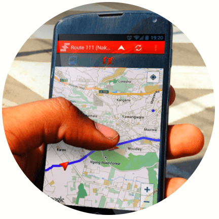
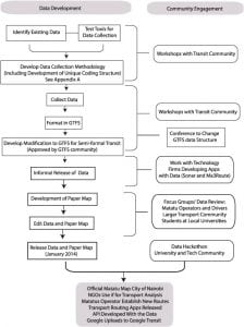
The mobile data collection was performed with a customized version of MyTracks.
Formatting of the data into the GTFS (General Transit Feed Specification) was initially done by hand. Currently, a web based application, Digital Matatus GTFS Editing Tool, simplifies the formatting process.
The GTFs editing tool is complete and was used to do the first update of Digital Matatus. The company has yet to launch it formally but intends to make it open source.Interview with representative
Digital Matatus utilizes data collected from partners to continuously update the data set to keep it as current as possible.
Intellectural Property Type
Open-source
User Provision Model
End users can use several apps that have implemented Digital Matatus' data:
- Google Maps
- Ma3Route
- Transit App
Distributions to Date Status
There have been over 5,000 downloads of the data and paper maps since 2014.
Geocoding supported (Y/N)
Yes
Visuals
Transit map
Application
Public transportation, GIS
Type of data collected
Geolocation, transit information
Data acquisition methods
Partner datasets, GPS, mobile data collection
Open source code (Y/N)
Yes
Open source data (Y /N/ Other)
Yes
Data import/export formats
GIS data, .gdb, GTFS data and text files. Full data export available for download.
Telecommunication service required (Y/N)
Mobile data or Internet access
Device(s) required
Smartphone, tablet, or computer
Languages available (list)
English
Design Specifications
Through a pre-selected mobile application, students from University of Nairobi rode several Matatus routes with mobile phones in their hands. The stops were identified as well. With the collected data, and after workshops with local transit experts, a more flexible GTFS standard was created. This standard is suitable for transit systems with high level of complexity and informality, such as Nairobi's.
Digital Matatus also designed a paper map at the Civic Data Design LabInterview with representative . Below are the steps towards achieving this solution:
1) Inspiration came from transit maps of systems in New York or London
2) Crowdsourced data was transferred into a software like Illustrator or Rhinoceros (Digital Matatus used Rhinoceros)
3) A grid was laid down and lines drawn at 45 and 90 degree angles on top of the grid
4) Colored lines were created for each group of routes
5) Stops for each line in the transit system was inserted
Product Schematics
Technical Support
Digital Matatus provides access to the GTFS datasets. General guidelines from the World Bank for integrating GTFS data into other applications is also provided.
Replacement Components
N/A
Lifecycle
N/A
Manufacturer Specified Performance Parameters
Digital Matatus intents to improve public transit in cities through technology, namely by using information gathered from the commuters.
Vetted Performance Status
From survey data: - 80% of respondents didn't have access to these data before the project - 86% of respondents believed the map made it easier to use public transit in Nairobi - 83% of respondents reported that they would try alternate Matatu routes with the map - 50% of respondents reported that they believed that Nairobi's Matatu system was better than they previously thought after seeing the map
Safety
N/A
Complementary Technical Systems
Google Maps, Open Street Maps
Academic Research and References
Klopp, J., Williams, S., 2016, Leveraging Cellphones for Wayfinding and Journey Planning in Semi-formal Bus Systems: Lessons from Digital Matatus in Nairobi. In: Planning Support Systems and Smart Cities. SPRINGER INTERNATIONAL PU
Williams, A., Waiganjo, P., Orwa, D., Klopp, J., 2015, The digital matatu project: Using cell phones to create an open source data for Nairobi’s semi-formal bus system, Journal of Transport Geography, Volume 49, Pages 39-51, ISSN 0966-6923
Klopp, J., Mutua, J., Orwa, D., Waiganjo. P,, White. A,, Williams, S., 2014, Towards a Standard for Paratransit Data: Lessons from Developing GTFS Data for Nairobi’s Matatu System. Transportation Research Board 93rd Annual Meeting
Klopp, J., Mutua, J., Orwa, D., Waiganjo. P,, White. A,, Williams, S., 2017, Informal 2.0: Seeing and Improving Urban Informal Practices through Digital Technologies The Digital Matatus case in Nairobi, The Journal of Field Actions, p. 39-43
“Competitive landscape – About Google Transit.” n.d. Google.com. Accessed June 12, 2024. https://support.google.com/transitpartners/answer/1111471
“Competitive landscape – Bing Maps.” n.d. Bing Maps. Accessed June 12, 2024. https://www.bing.com/maps?cp=-1.949697%7E30.06752&lvl=11.0
“Competitive landscape – Maps.” n.d. Apple. Accessed June 12, 2024. https://www.apple.com/maps/
“Goal 9.” n.d. Sdgs.Un.Org. Accessed June 12, 2024. https://sdgs.un.org/goals/goal9
“Goal 11.” n.d. Sdgs.Un.Org. Accessed June 12, 2024. https://sdgs.un.org/goals/goal11
“My Track.” n.d. Google.Com. Accessed June 12, 2024. https://play.google.com/store/apps/details?id=com.zihua.android.mytracks&hl=en
“DIGITAL MATATUS.” n.d. Digitalmatatus.Com. Accessed June 12, 2024. http://digitalmatatus.com/post10.html
“Transit • Make Life Better without a Car.” n.d. Transitapp.Com. Accessed June 12, 2024. https://transitapp.com/
“DIGITAL MATATUS.” n.d. Digitalmatatus.Com. Accessed June 12, 2024. http://digitalmatatus.com/about.html
“DIGITAL MATATUS.” n.d. Digitalmatatus.Com. Accessed June 12, 2024. http://digitalmatatus.com/map.html
Williams, Sarah. 2013. “Ditigial Matatus: Developing Open Data for Informal Transit Systems.” Vimeo. April 5, 2013. https://vimeo.com/63423795
“Adobe Illustrator – Industry-Leading Vector Graphics Software.” n.d. Adobe.Com. Accessed June 12, 2024. https://www.adobe.com/products/illustrator.html
McNeel, Robert, and Associates. n.d. “Rhinoceros 3D.” Www.Rhino3d.Com. Accessed June 12, 2024. https://www.rhino3d.com/
Link Repository for International GTFS Training Materials. n.d. Accessed June 12, 2024. https://github.com/WorldBank-Transport/GTFS-Training-Materials/wiki/Link-repository-for-international-GTFS-training-materials
“DIGITAL MATATUS.” n.d. Digitalmatatus.Com. Accessed June 12, 2024. http://digitalmatatus.com/vision.html
“DIGITAL MATATUS.” n.d. Digitalmatatus.Com. Accessed June 12, 2024. http://digitalmatatus.com/team.html
Compliance with regulations
N/A
Evaluation methods
Academic research, Field trials
Other Information
- World Bank training material on GTFS
- Wired article on Digital Matatus
Resources related to paper map:
Agriculture
August 4, 2024
Implemented by
Hatch International
Agriculture
June 23, 2024
Implemented by
Kiira Motors Corporation
Agriculture
June 18, 2024
Implemented by
SES S.A.
Agriculture
May 24, 2024
Implemented by
Arinifu (George Chege)
Agriculture
March 7, 2024
Implemented by
International Network for Bamboo and Rattan (INBAR)
Agriculture
June 19, 2024
Implemented by
BRCK
Agriculture
June 12, 2024
Implemented by
Skyfish
Agriculture
June 26, 2024
Implemented by
University of Philippines
Agriculture
June 1, 2024
Implemented by
Socialcops

Agriculture
March 14, 2024
Implemented by
Timbercrete
Have thoughts on how we can improve?
Give Us Feedback