Agriculture
June 4, 2024
Open Data Kit
Read SolutionImplemented by
University of Washington
Updated on June 20, 2024
·Created on June 26, 2017
Premise is a data analytics company that aims to use their platform to more accurately forecast markets and solve social issues. Their product
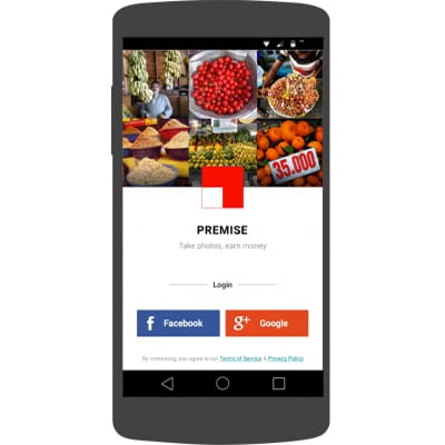
Premise platform collects market pricing information by crawling information from internet retailers worldwide. They also employ part-time workers in their global network to gather on the ground pricing information utilizing an android smartphone and their app.
Premise has also used it’s platform to begin a disease surveillance project, Citizen-led disease risk mapping and vector monitoring, as a part of the USAID “Combating Zika and Future Threats Grand Challenge”.
Target SDGs
SDG 16: Peace, Justice and Strong Institutions
SDG 17: Partnerships for the Goal
Target Users (Target Impact Group)
Small and Medium-sized Enterprises, Public Sector Agencies, NGOs
Distributors / Implementing Organizations
Premise Data works with government, commercial and NGO partners Interview with representative - USAID - US State Department - UN FAO
Regions
Worldwide
Manufacturing/Building Method
Premise is designed to combine the traditional web crawling data collection methods, but they combine that with contributors on the ground to give a different dimension to the data analysis.
Remote contributors take a picture of a desired data point and upload it to Premise's cloud infrastructure. They determine their data acquisition targets based on specific contract requirements. Whether it's market prices or conditions, mosquito conditions(standing water, discarded tires, etc.) or electrification in eastern Africa, their platform can consume that data and output useful analytics.
Intellectural Property Type
Copyright
User Provision Model
Premise provides the software as a service to their partners, backed by a partner-support and training team. For more information on partnering with Premise see their contact page
The Premise application can be downloaded from the Google Play Store
Distributions to Date Status
More than 25,000 contributors worldwide
Google Play Store reports 500 - 1,000 installs of the Android application
Areas of analysis
Consumer price indexes, infrastructure planning, disease risk mapping, remote workforce management
Data acquisition methods
Mobile data acquisition, web crawling, partner data sets
Open source code (Y/N/Other)
No
Open source data (Y/N/Other)
No
Subscription required for data aquisition (Y/N)
Yes
Additional organizations/companies used to publish or analyze the data? (Y/N)
No
Third party (User) data access
No
Design Specifications
Detailed methodology and documentation on Premise's Food Staples Index
According to siftery, Premise uses a combination of Google, Amazon, and several other cloud services to produce their analytics.
Technical Support
Premise provides support as a part of the subscription.
Replacement Components
N/A
Lifecycle
N/A
Manufacturer Specified Performance Parameters
- To utilize their data collection and analytics platform to provide actionable data to decision makers.
- Provide near real-time analytics on market prices, food security, free and open election process or other applicable social issues
Vetted Performance Status
In the FAO's comparison, "Timeliness leans in favor of Premise, both because the FSI is a daily index, and because it can make available a monthly index similar to the food CPI 10 days before month end and up to 25 days before the official Instituto Brasileiro de Geografia e Estatistica release."
Safety
N/A
Complementary Technical Systems
N/A
Academic Research and References
“Premise – Data for Every DecisionTM.” n.d. Premise. Accessed June 20, 2024. https://premise.com/
“Oracle Marketing.” n.d. Oracle.Com. Accessed June 20, 2024. https://www.oracle.com/cx/marketing/
“Quid: AI-Powered Consumer and Market Intelligence.” n.d. Quid.Com. Accessed June 20, 2024. https://www.quid.com
“Goal 16.” n.d. Sdgs.Un.Org. Accessed June 20, 2024. https://sdgs.un.org/goals/goal16
“Goal 17.” n.d. Sdgs.Un.Org. Accessed June 20, 2024. https://sdgs.un.org/goals/goal17
“CPG In-Store Insights Case Studies.” n.d. Premise. Accessed June 20, 2024. https://premise.com/cpg/case-study/
“Contact Us – Sales, Support & Customer Service.” n.d. Premise. Accessed June 20, 2024. https://premise.com/get-in-touch/
“Premise – Earn Money for Tasks.” n.d. Google.Com. Accessed June 20, 2024. https://play.google.com/store/apps/details?id=com.premise.android.prod
Kelly, Heather. 2016. “How ?Pictures of Cigarettes Can Set Economic Policy.” CNNMoney. May 25, 2016. https://money.cnn.com/2016/05/25/technology/premise-economic-crowdsourcing/
“Accueil.” n.d. FAOHome. Accessed June 20, 2024. https://www.fao.org/home/fr
“Privacy Policy.” n.d. Premise.Com. Accessed June 20, 2024. https://tos.premise.com/privacy-policy/en/
“Blogs Archive.” n.d. Premise. Accessed June 20, 2024. https://premise.com/blog/
Compliance with regulations
According to the Premise Terms of Use and the Premise Privacy Policy they comply with all applicable laws and regulations
Evaluation methods
Field trials
Other Information
– Engineering for Change Webinar – Premise
– SF Gate article on Premise’s background
– TechCrunch article with more background information
– Wired article on food price index

Agriculture
June 4, 2024
Implemented by
University of Washington
Agriculture
February 15, 2024
Implemented by
HemoCue

Agriculture
June 26, 2024
Implemented by
OCHA

Agriculture
June 26, 2024
Implemented by
CGNet Swara

Agriculture
June 24, 2024
Implemented by
FixMyStreet

Agriculture
June 25, 2024
Implemented by
RootIO

Agriculture
June 24, 2024
Implemented by
UNICEF

Agriculture
June 26, 2024
Implemented by
Digicel

Agriculture
June 1, 2024
Implemented by
Salanga

Agriculture
June 23, 2024
Implemented by
Mobenzi Technologies
Have thoughts on how we can improve?
Give Us Feedback
Premise
Premise makes use of crowdsourced observations from a community of users who record and verify information such as market prices and mosquito breeding sites, although economic applications are the strongest use case. The added value here is increased time and space resolved data points. This is done using Android phones and purpose built software that records visual evidence and verifies the content using geolocation and analysis of meta-data such as timestamps. The platform is live in 30 countries including South America and Africa, although it is necessarily limited to areas with reasonable Android penetration.
End users include NGOs and governmental agencies, data is accessed via a clean and well designed dashboard. The organisation is a social enterprise but its business model sells these insights for profit and the platform is proprietary.
A potential weakness in the platform arises from the ability to rapidly scale up to new locations and countries. There must be a critical mass of users to make accurate predictions, and those users must be compelled to recruit other users. This process is somewhat fragile and unpredictable. However, deep analysis of visual information has much to add, for example a picture of a shelf in a supermarket can identify not only prices, but brands available, their relative popularity and so on.
Flowminder
Flowminder is a foundation that analyses non-traditional data sources such as (anonymised) mobile phone records and satellite imagery to provide data with high spatial and temporal accuracy. This relies on state of the art techniques from academia that are applied to areas such as population density, age distribution and migration.
Specific cases include the combination of detailed census data that may be 10 years old, a country level total population estimate from a demographic institute and satellite imagery. Numerical techniques exist to combine these in such a way that up to date, sub-national data may be inferred.
Flowminder describes its methodologies in open access scientific journals and all data products are freely available via a very easy to use and highly available data portal. These can be used for downstream analysis in GIS or other software. Generally the ideal user is data literate and able to write basic code for analysis.
New data products and analyses are in response to requests and funding from organisations such as Gates Foundation.
Akvo RSR
Akvo RSR (Really Simple Reporting) is a tool that allows easy synthesis and publishing of data collected for Monitoring and Evaluation purposes. It is a not for profit foundation (the US arm is a 501(3)c organisation) that offers RSR alongside other products.
RSR allows all projects to be managed together including milestones, metrics, project management and associated data whether structured (e.g. CSV) or rich (images, videos, documents).
RSR offers a tool that is purpose built for complex development projects with multiple stakeholders. The ability to easily share reports via a website allows for constant updating of results. The software is priced according to the number of projects to be managed, beginning at 2,800 EUR per year for 20 projects.
Myanmar Information Management Unit
MIMU is a portal that hosts data from Myanmar on development projects from various sectors including agriculture, gender, governance and WASH. It is an effort of the UN resident coordinator’s office in Myanmar. The purpose is to compile data from various humanitarian and development projects across the country, for which the UN resident coordinator is uniquely positioned to provide a bird’s eye view.
The available data covers structured data, textual reports and spatial data such as maps and is focused along the 3Ws of Who does What, Where. This is combined with baseline data on demographic information such as population.
While limited to a single country, this appears to be a comprehensive source of information for Myanmar. The model of UN Resident Coordinator led portals to combine data and projects underway is valuable. An ideal beneficiary would not only be a consumer of currently available data, but also a funding organisation seeking to fill knowledge gaps by surveying ongoing projects.
aWhere
aWhere is an established agricultural intelligence company having operated for nearly 20 years. The main value added is the synthesis of weather and agricultural signals to provide information to farmers and small land owners on expected yields and predicted agricultural information. This is delivered through a dashboard, with an associated API for developers, and an SMS alert delivery platform.
aWhere does offer services aimed directly at developing countries and markets susceptible to food insecurity, however the core market appears to be the US and it is not clear the data that is used outside of these developed markets where high resolution data on weather and land cover are not reliable.
aWhere offers deep knowledge on agritech, developed over many years with strong leadership on core science but appears to be relatively inexperienced in developing markets.
WhereIsMyTransport
WhereIsMyTransport is a platform that collects information on transport routes, schedules and fares in 21 countries across the Middle East and Africa. The data appears to be collected both passively, using GPS devices and actively from user volunteered data such as prices via a mobile app. This is applied to both formal networks such as public funded routes as well as informal routes from private operators. Previously mobility has been mapped using expensive and sparse surveys or data collected passively from mobile phones which is proprietary, sensitive and potentially skewed.
This is a valuable service as an understanding of urban mobility is critical for many downstream development outcomes from crime to air quality. Often public services are not able to answer demand and informal and flexible services offered by 3rd parties meet this demand.
The service offers an API for developers to build upon which is free. This positions the platform well for uptake by developers and 3rd parties.